
On March 6, 2018, the Subcommittee on Zoning and Franchises and the Committee on Land Use approved modifications to the Department of City Planning’s (DCP) rezoning plan and Council Members Gibson and Cabrera reached an agreement with the Administration on a set of neighborhood investments. The modification to the zoning text amendment removes MIH Option 2 from the area, and changes the height, setback and floor area regulations for R8A districts in order to maintain the previously applicable R8 quality housing regulations. The modified application will be voted on by the full City Council on March 21, 2018.
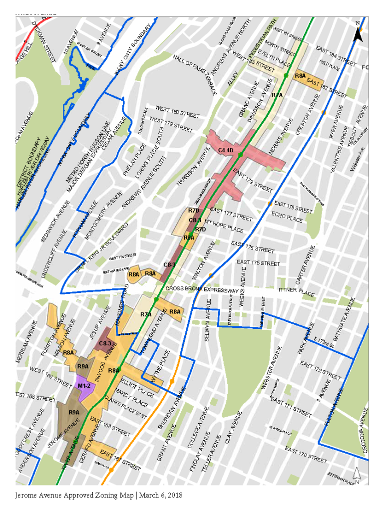
The Jerome Avenue rezoning plan reflects years of community-based planning aimed at addressing pressing neighborhood challenges, including the preservation and creation of affordable housing, spurring local economic development, and investments in schools, open spaces, streetscape and transportation infrastructure. The plan called for rezoning an approximately 95-block area that spans Jerome Avenue and includes portions of Council Member Vanessa Gibson’s 16th District, and Council Member Fernando Cabrera’s 14th District. The rezoning area is generally bounded by McClellan Street to the south and 184th Street to the north, and includes portions of Edward L. Grant Highway, E 170th Street, Mount Eden Avenue, Tremont Avenue, Burnside Avenue and E 183rd street.
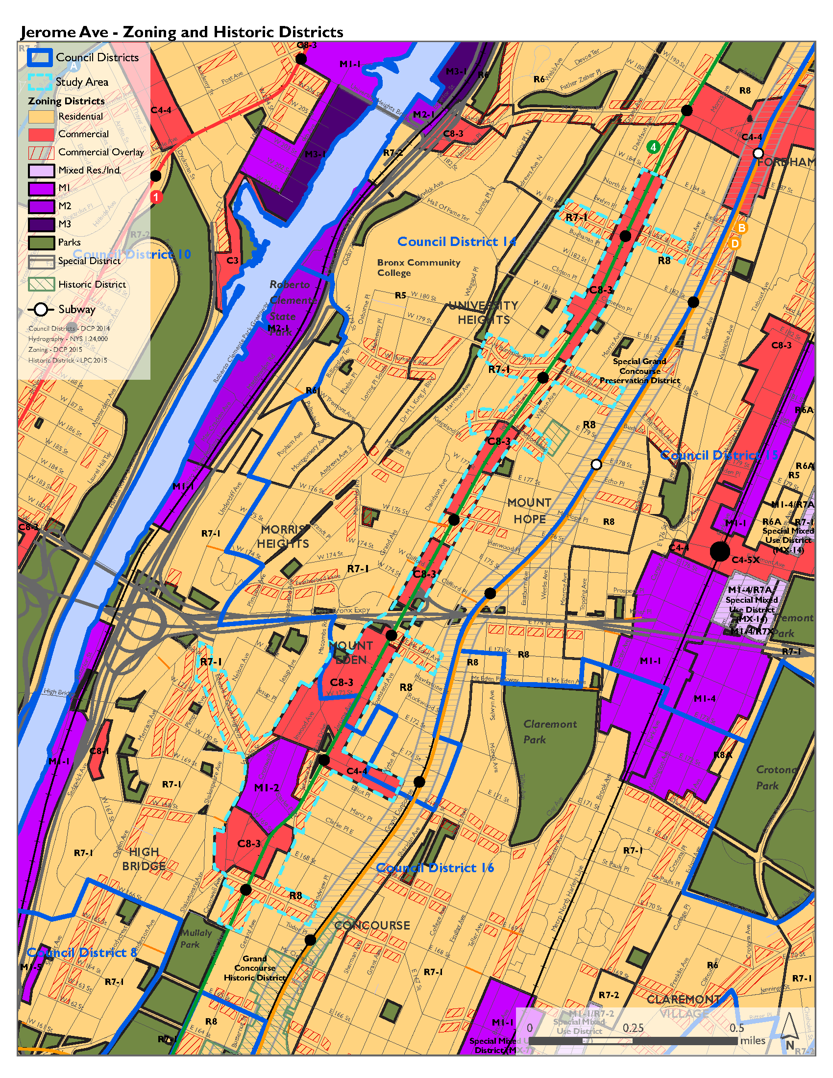
Current Jerome Ave Zoning and Historic Districts
The City’s Land Use Review Process
Certain changes in land use require a public review process called the Uniform Land Use Review Procedure (ULURP). The ULURP process provides an opportunity for the public to consider the impact that land use changes, such as a rezoning, may have on the surrounding neighborhood and provide feedback. It also sets a mandated timeline for the local Community Board, Borough President, City Planning Commission and City Council to review, host hearings and vote on the proposed land use change.
Learn more about the ULURP process from the City Council and in this guide (PDF) from the Department of City Planning.
The Department of City Planning Proposal
The Department of City Planning (DCP) released its proposal on August 21, 2017. DCP’s land use application proposed zoning changes to allow for greater density along the corridor, where the Mandatory Inclusionary Housing (MIH) program would apply, requiring private property owners to provide income restricted housing for a portion of the units in any new development.
The actions also proposed to establish the new Special Jerome Avenue District that would impose special use controls to the ground floors of buildings within commercial areas, modify bulk and height regulations on lots fronting the elevated rail line, modify bulk regulations on irregular lots, and establish additional controls, like discretionary review provisions for transient hotels.
Finally, the proposal sought a City Map change to demap Corporal Irwin Fischer Place between Nelson and Shakespeare Avenue, and propose mapping of Block 2520, Lot 19 as parkland to facilitate the development of Corporal Fischer Park.
On November 1, 2017, DCP submitted an amended version of their proposal, known as an “A-application”. The modified zoning text amendment (N180050(A) ZRX), maintains the provisions of the originally filed application, as well as allowing 2nd story retail along the Jerome Avenue in mixed-use buildings, and allowing the 2nd story as a permitted obstruction in the rear yard within 100’ of Jerome Avenue. Additionally, the modified zoning text permits physical culture establishments (aka gyms) as-of-right, and provides design flexibility for a large, irregular lot in Community District 5. Further, the zoning map amendment was modified (C180051(A)ZMX) and proposed to extend the rezoning boundaries in three locations, which would allow for additional development projects.
Community Board, Borough President, and City Planning Feedback
Bronx Community Boards 4, 5, and 7 Recommendations (October 2017)
- Community Board 4 Recommendation (PDF)
- Community Board 5 Recommendation (PDF)
- Community Board 7 Recommendation (PDF)
Bronx Borough President Ruben Diaz Jr. Recommendation (November 2017)
Borough President Recommendation (PDF)
City Planning Commission Report (January 2018)
City Planning Commission Report Zoning Map Amendment Report (PDF)
City Planning Commission Zoning Text Report (PDF)
City Planning Commission City Map Amendment Report (PDF)
Role of the Council
Through its role in the ULURP process, the City Council has the ability to approve, modify, or disapprove DCP’s rezoning proposal. However, any modifications made by the City Council must be “within scope”—which means that any proposed changes had to be studied in the Final Environmental Impact Statement (FEIS).
The City Council held a public hearing at City Hall on this proposal on February 7, 2018. The Subcommittee on Zoning and Franchises and Committee on Land Use approved the rezoning applications, with modifications on March 6, 2018. The full City Council will vote on the modified applications on March 21, 2018.
Implementation and Commitment Tracker
In addition to approving a modified rezoning proposal, Council Members Gibson and Cabrera secured additional commitments from the Administration for critical neighborhood investment. These commitments will be tracked and annual reports will be issued on their progress, for a full list of the Administration’s commitments click here.*
*Item 36 in the Administration’s Commitment Letter incorrectly refers to the “JobsFirst Network” rather than “JobsFirstNYC”.